


Map & Directions to Camp
Click for interactive Google map
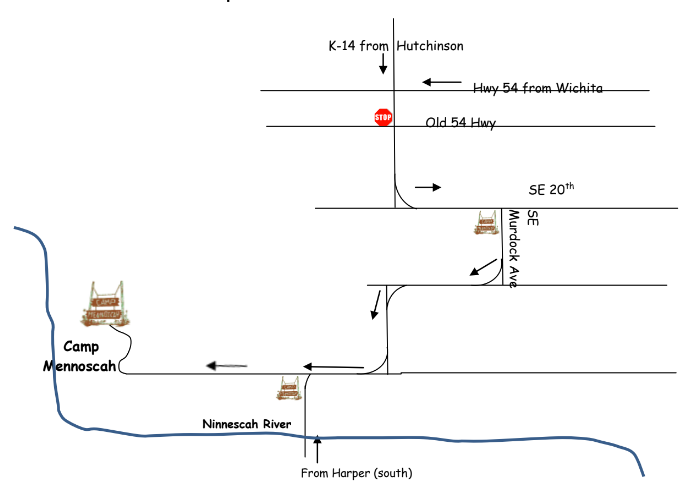
PLEASE NOTE: The highway that was previously K-17 (Hutchinson to Murdock) is now K-14.
from Wichita: Take Hwy 54 West to K-14 (Hutchinson/Murdock exit). Turn left (south); go straight (past stop sign) across Old Hwy 54. Turn right (south) onto SE Murdock at the first Camp Mennoscah sign and continue through Murdock on blacktop road until you get to the 2nd Camp Mennoscah sign. Turn off onto the dirt road and follow to camp driveway.
from Hutchinson: Take K-14 South about 30 miles and turn right (south) onto SE Murdock at the first Camp Mennoscah sign and continue through Murdock on blacktop road until you get to the 2nd Camp Mennoscah sign. Turn off onto the dirt road and follow to camp driveway.
from the west/Kingman: Take Hwy 54 East to K-14 (Hutchinson/Murdock exit). Turn right (south); go straight (past stop sign) across Old Hwy 54. Turn right (south) onto SE Murdock at the first Camp Mennoscah sign and continue through Murdock on blacktop road until you get to the 2nd Camp Mennoscah sign. Turn off onto the dirt road and follow to camp driveway.
from the south/Harper: Take K-14 north. Turn right (east) onto K-42. Go through Adams. Turn left (north) onto SE 100th Ave. Go approximately 9 miles. The Camp Mennoscah sign will be on the left. Turn off onto the dirt road and follow to camp driveway.
GPS Coordinates
37° 35’ 36” N
97° 56’ 51” W
